Как определить, где находится спутник Триклор, МТС, НТВ и проверить отсутствие препятствий для установки антенны.
Определение направления по карте
Сначала находим направление на спутник на карте. Для этого лучше всего подходит сервис MapSat (mapsat.ru).
- Укажите название спутника.
Выберите в списке “Выбор спутника” название (координаты) интересующего Вас спутника, либо укажите название оператора спутникового телевидения (например МТС, Триколор ТВ, НТВ+)
- Найдите на карте адрес установки антенны.
Для поиска координат установки спутниковой антенны на карте введите адрес объекта в поле “Адрес или объект”(находится в верхней левой части карты). В случае, если система найдет несколько адресов подходящих под параметры поиска, Вам будет предложено выбрать один из них. При выборе требуемого адреса карта автоматически настроится на интересующий Вас объект.Альтернативный метод поиска текущего адреса — использование кнопки “Определить местоположение”. Метод особенно эффективен если Вы находитесь рядом с местом где будет производиться настройка спутниковой антенны, а для доступа к карте используется устройство оснащенное GPS (например смартфон или планшет). В этом случае центр карты будет перемещен в точку с координатами полученными с GPS устройства.
- Укажите точное место монтажа спутниковой антенны
На спутниковой карте необходимо как можно точнее задать координаты места установки антенны. Для этого увеличивается масштаб карты, “Тип карты” переключается в режим отображения спутниковых снимков Google Map или Yandex Map (в зависимости от того какая карта более детализирована для вашего региона). Левой кнопкой мыши отмечается точка монтажа спутниковой тарелки. В указанном месте появится маркер с линией направленной в сторону спутника. Расположение маркера можно изменять, перетаскивая его по карте.Убедитесь что приему спутникового сигнала ничего не мешает — линия направления на спутник не пересекает крупные деревья, высокие здания и т.п.. Если линия пересекает крупный объект, необходимо удостовериться в том, что он не будет мешать приему сигнала. Для этого можно воспользоваться кнопкой “Расчет препятствий”. Перетащите маркер, символизирующий препятствие, на исследуемый объект. В графе “Высота преодолеваемого препятствия” будет рассчитана максимальная высота объекта, который не будет мешать приему. Если объект, расположенный на пути приема сигнала со спутника, возвышается над антенной больше данного значения, он может препятствовать приему. В таком случае придется увеличить высоту установки антенны, либо выбрать другое место.
Программы (приложения) для настройки спутникового ТВ
SatFinder — cамое популярное приложение. Есть версии для iOS и Android. К сожалению, популярность породила множество клонов этой программы с таким же или похожими названиями, но сильно уступающих по качеству. Программа бесплатная, с простым и понятным интерфейсом. Отлично определяет направление на спутник, при этом, в отличие от многих других приложений, есть возможность выбора конкретного спутника. Единственное, для использования SatFinder нужен смартфон с хорошим экраном, в обратном случае на нем будут плохо видны спутники.
Как пользоваться
Скачайте SatFinder. Запустите приложения и, держа смартфон вертикально, подождите, пока программа определит ваше местонахождение. На вашем смартфоне должна работать функция GPS.
Далее выберите спутник (МТС — ABS-2A, Триколор, НТВ+ — Eutelsat 36B/36C (Express-AMU1)) в меню приложения, и оно поможет вам направить антенну точно по координатам выбранного спутника. Желтые стрелки будут указывать направление, в котором следует перемещать смартфон, пока он не станет направлен точно на спутник, после чего цвет стрелок изменится на зеленый, и вы услышите звуковой сигнал. Далее необходимо будет повернуть антенну в нужном направлении.


На видео демонстрируется работа приложения SatFinder

(Image credit: jxfzsy via Getty Images)
The night sky is becoming increasingly busy! If you spend any time gazing at the stars on a clear night, you’re guaranteed to see a satellite or two passing among them. But how do you know whether that’s a spent rocket booster, the Hubble Space Telescope, or a crewed space station gliding silently overhead? And what was that momentary flash of light? Was it a meteor — or the glint from a shiny satellite?
Since the first artificial satellite, the Soviet Union’s Sputnik 1, kicked off the space age on Oct. 4, 1957, thousands of objects have been launched into orbit. Many of these were satellites for scientific, telecommunication, and military uses, while the rest consisted of spent rocket boosters and other space debris. The largest object by far is the International Space Station (ISS). This 490-ton (444 metric tons) crewed orbiting space laboratory is about the size of a football field (including the end zones) and includes an acre of solar panels! At the other end of the scale are tiny CubeSats measuring only 4 inches (10 centimeters) on each side.
Related: How to see and track the International Space Station (ISS)
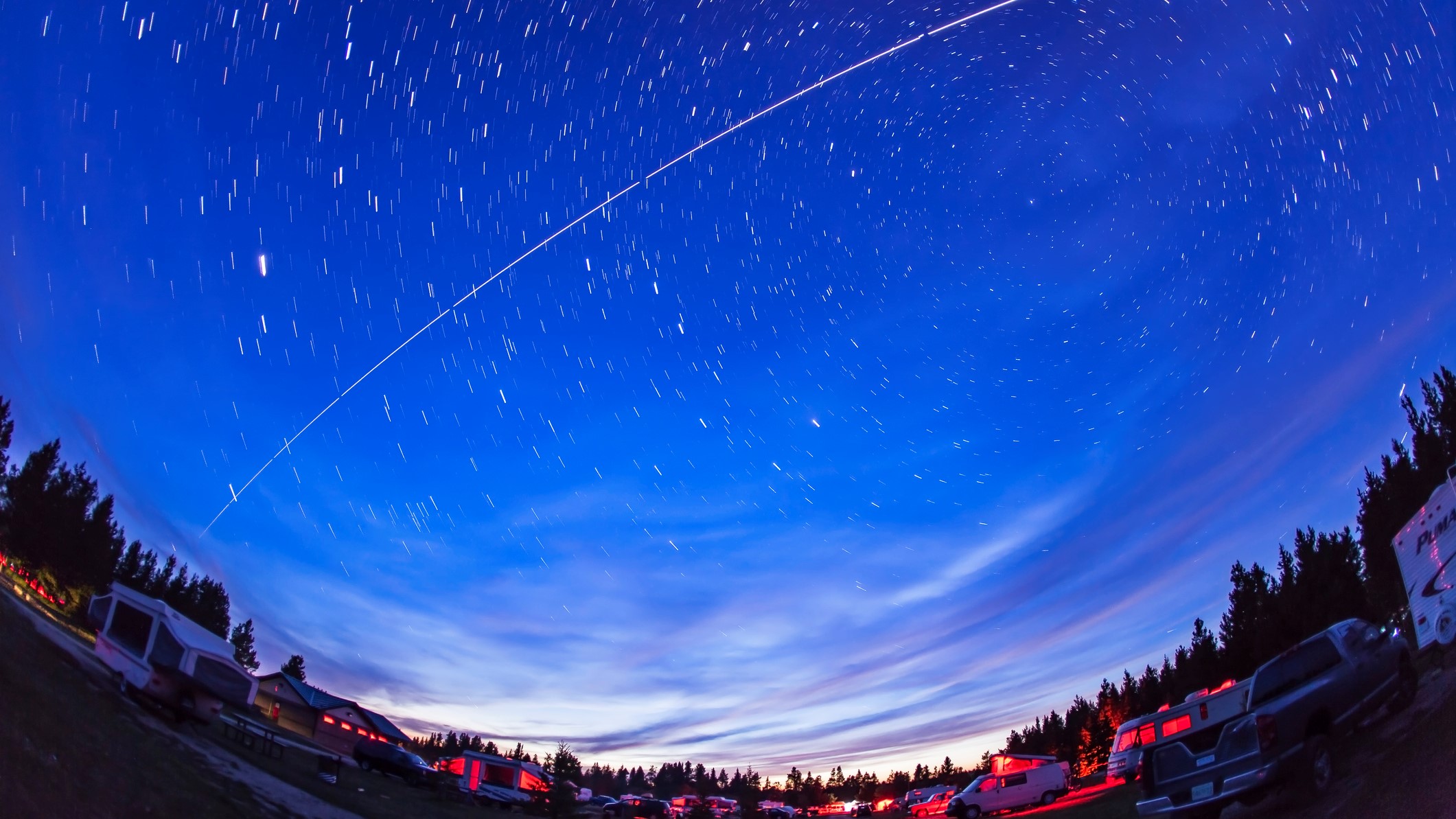
Recently, SpaceX and several other commercial operators have begun launching thousands of communications satellites designed to deliver broadband Internet access across the globe. While most of those aren’t particularly bright, the SpaceX Starlink satellites frequently create a buzz among skywatchers immediately after they are launched. Before they spread out into their final orbits they appear as long chains of dots moving together across the night sky.
Since everyone carries a phone around with them, mobile apps are ideal tools for tracking the satellites that are visible with unaided eyes. They can tell you which object you are seeing (or saw earlier), alert you just before a space station will appear in the night sky and show you exactly where to look for it.
The most useful satellite apps utilize your device’s compass and gyroscope to guide you where to look in the sky for satellites — a necessity when sharing the fun of satellite-watching with friends and family, or at star parties. Let’s look at the best mobile apps for spotting these artificial denizens of the night sky. But first, some satellite basics!
What’s that light?
Orbiting satellites are visible to us because they are high enough overhead to be illuminated by sunlight, even when the sun is below the horizon for ground observers. That’s why most satellites are seen an hour or two before dawn and after dusk. When a passing satellite seems to disappear, it has entered Earth‘s shadow — a circular patch of the sky where the sunlight can’t reach it. Satellites can also pop into view when they exit the shadow.
The brightness of a satellite depends on its distance from you and on how much sunlight it deflects toward you, which is a function of both its flat surface area and reflectivity. Most satellites shine with a steady light, but objects that are tumbling can glow and darken as they travel. Other than crewed vehicles, satellites do not have lights — and no artificial light in orbit would be bright enough to spot from the ground anyway. If you see an object with flashing lights, it’s an aircraft.
Telecommunication and some surveillance satellites have geosynchronous orbits designed to keep them in view from the same spot on Earth at all times. To do this, they need to orbit above Earth’s equator, at 22,236 miles (35,786 km) above sea level. At that range, this type of satellite will be dim. While observing with your telescope, you might spot one moving very slowly against the background stars. In the night sky, geosynchronous satellites are concentrated in a strip running several degrees below the celestial equator. At their extremely distant orbits, the Earth’s shadow covers only a small patch of the sky, so they can appear all night long. These are the satellites that you aim your satellite TV dish at. When searching the app store, you’ll find many apps designed for that purpose, and not skywatching.
Spacecraft that need to move around the Earth at a modest rate orbit closer in, around 12,600 miles (20,200 km) above sea level. This includes the 31 Global Positioning System (GPS) satellites, and the satellites in the navigation networks of Russia (GLONASS), Europe (Galileo), China (BeiDou), India (NavIC) and Japan (QZSS). Those satellites pass over the same spot on Earth every 12 hours and are not observable to the naked eye, but they can zip through your telescope’s field.
Satellites that need to closely observe Earth’s surface and weather, or that are too heavy to lift into high orbits, are placed in low Earth orbit (LEO). These are the bright satellites you’ll see zipping across the night sky. Low Earth orbits fall into a range. To minimize drag on spacecraft from the upper atmosphere and allow for high-resolution close-up views of our planet, 190 miles (300 km) is the lower limit. The upper limit is about 1,250 miles (2,000 km), just inside the protective shell of Earth’s Van Allen radiation belts.
Satellites in LEO need to move fast, taking between 90 and 225 minutes to complete one orbit of Earth. Well-known examples are the ISS, the Hubble Space Telescope, China’s Tiangong Space Station, National Oceanic Atmospheric Administration weather satellites, Landsat (used for Google Maps), Iridium satellites, and Europe’s Envisat. The American Atlas-Centaur and Russian COSMOS (sometimes spelled Kosmos) and Breeze (sometimes spelled Briz) expended rocket upper stages also fall into this class.
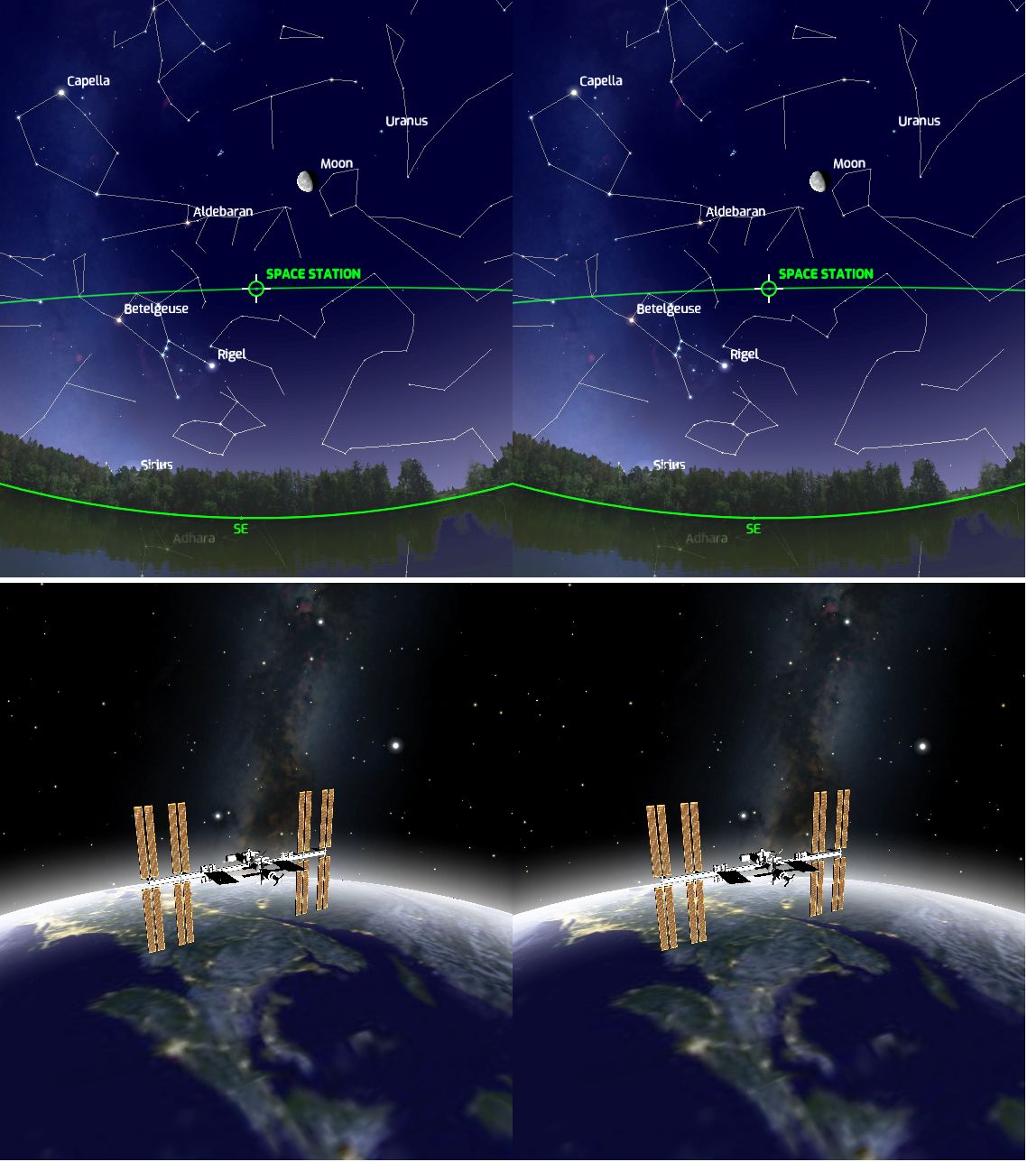
The ISS was assembled by launching individual modules and connecting them in orbit. The first component, dubbed Zarya (which means «sunrise» in Russian), was launched on a Russian rocket on Nov. 20, 1998, so many satellite apps refer to the ISS as Zarya. Another name you’ll see is Nauka, the name of Roscosmos’ Multipurpose Laboratory Module-Upgrade that was added on July 29, 2021. The space station’s solar panel arrays rotate constantly to keep them aimed toward the sun, and reflections from them produce the steady glow we see as it flies overhead. The ISS is the most easily observable man-made object. In the night sky, only the moon and Venus shine brighter.
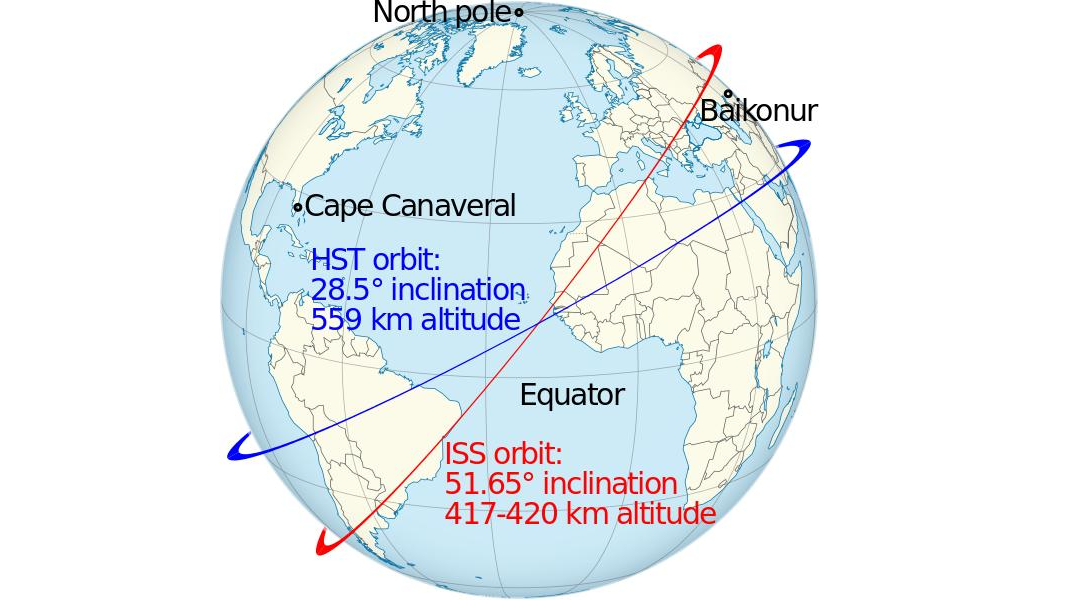
The ISS’ orbit is approximately 250 miles (402 km) high, according to NASA, so it is one of the objects that completes one orbit of the Earth every 92.5 minutes (or 16 per day). When the ISS completes one orbit, the Earth has rotated to the east by 22.5 degrees. By tilting the station’s orbit with respect to the Earth’s equator, a series of diagonal strips are covered, with each strip west of the previous one. That way, almost all of Earth’s surface will be flown over every few days.
The ISS’ orbit is inclined 51.6 degrees from the equator, so it only travels roughly between the Kamchatka Peninsula and the Falkland Islands. While it passes over the same spot on Earth every three days, the time when it does so drifts, so it takes 63 days for the space station to reappear over your house at the same time of night. The station need not be straight overhead to see it, though. One or two passes east and west of your location should be visible, too, if conditions are right — often giving us two or even three sightings on the same day.
ISS-tracking apps know the orbital details and work out the geometry of the sun’s position, and your location, to predict sightings for you. Higher passes are always brighter and longer — up to 5 minutes from horizon to horizon, often passing nearly overhead. For passes well east or west of your location, the station’s maximum elevation above the horizon will be so low that it might only be visible for a minute or less, or hidden completely by trees or buildings. The app will indicate the maximum height above the horizon in degrees, the direction of motion and the duration. Most apps offer an icon to distinguish a high-quality pass from a mediocre one. The better apps allow you to filter out the poor sightings.
The Chinese Tiangong Space Station was launched in April 2021. Components will continue to be added over the coming several years. As of spring, 2022 only the Tianhe core module, with a mass of 24.5 tons (22.6 tonnes) and dimensions of 54 by 14 feet (16.6 by 4.2 meters), is in orbit at a mean altitude of 241 miles (389 km). It swings between 41.58 degrees north and south latitude, circling the globe every 92 minutes. That makes Tianhe far less bright than ISS, and only observable from latitudes within about 45 degrees of the equator.
Next, we’ll look at two of the best apps for satellite skywatchers.
Orbitrack
The Orbitrack app, available for Apple products and Android devices, is the most powerful and comprehensive satellite tracking app I’ve found. It’s from Southern Stars, the developer of the popular SkySafari app. Users of that app will already be accustomed to its user interface because the main toolbar looks almost the same.
The app tracks every active orbiting satellite and man-made object that is large enough to be visible. As with SkySafari, all data is stored locally, allowing you to use the app without a data connection. Orbitrack automatically adds new objects as they are launched, such as Dragon crewed and cargo deliveries to ISS, and it updates satellites’ orbits that change over time. Everything is included for an inexpensive, one-time purchase price.
Orbitrack’s Search menu begins with Special Interest Satellites, those that will be visible tonight, newly launched satellites, space stations, and bright satellites. Next up are sections for Weather & Earth Resources, Communication, Navigation, Scientific, and Miscellaneous satellites, each divided into sub-categories with the entries listed in alphabetical order. Satellites that are above your horizon now are highlighted with brighter text. You can also find an individual satellite (or family of satellites) by entering all or a portion of the name into the search bar.
The page for each satellite includes an Object Info tab containing the physical characteristics of the satellite, its position in the sky, the location on Earth it is flying over, and its orbital parameters. Scroll down to find the upcoming passes. Tap the clock icon for the rise, culminate, set, or eclipsed time to show the sky at that time or set an alert for the pass. An Object Description tab opens a page with details about the satellite’s history and photographs of selected satellites.
Alerts appear on your device’s lock screen. In the main Settings menu, you can adjust the amount of advanced warning time (the default is 1 minute) and view and cancel alerts. I recommend enabling Sort Lists by Pass Time and showing Visible Passes Only — unless you are a Ham radio operator who wants to know when satellites are passing during the daytime.
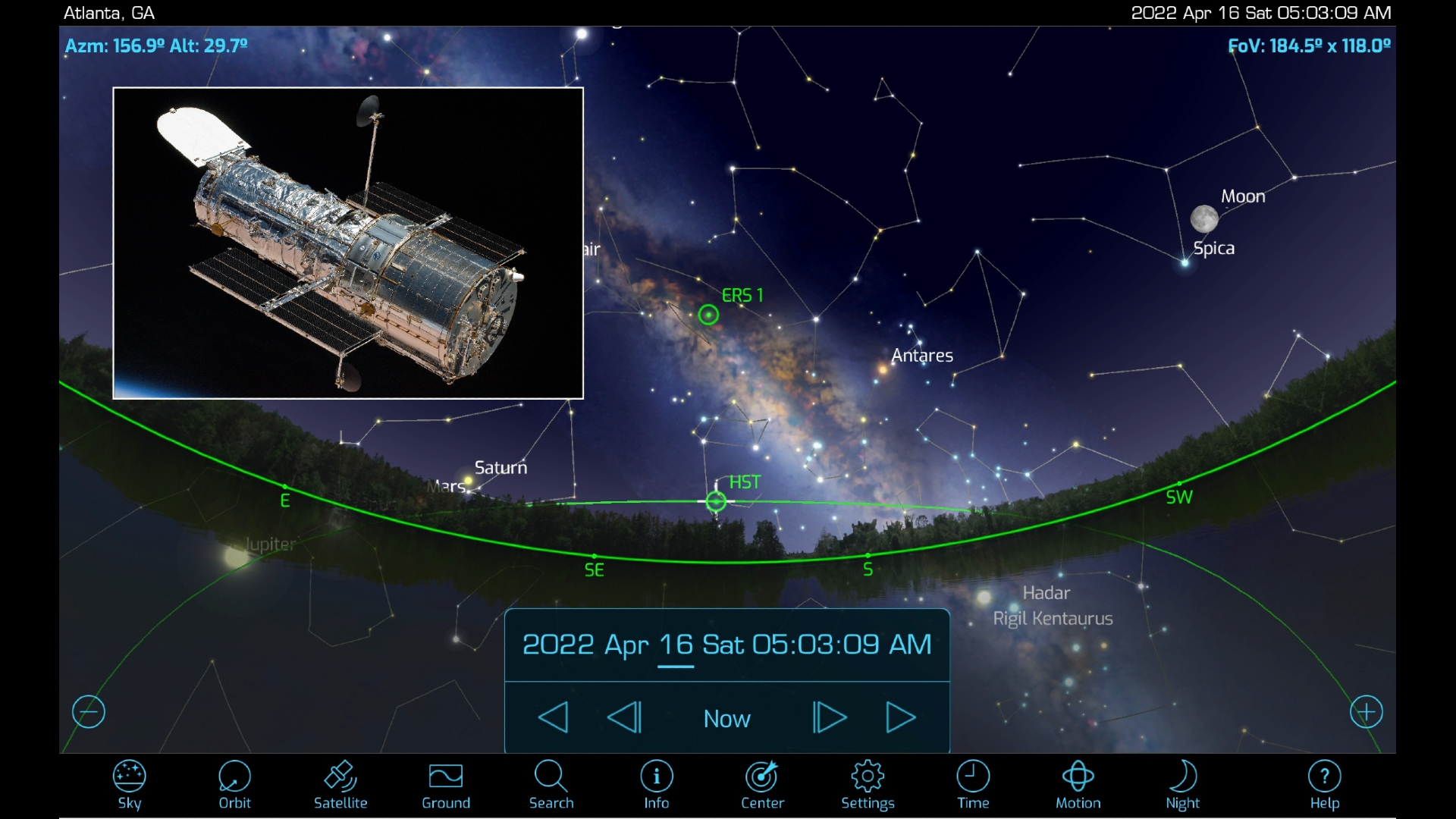
Orbitrack displays satellites in four modes: Sky View, Orbit View, Satellite View, and Ground View, each enabled by tapping icons on the toolbar.
Sky View displays the sky at your location, or from any other location in the app’s database. Satellites are shown with labeled green symbols. There’s an option to also draw the selected satellite’s orbit, which is my preference. The number of satellites shown can be controlled by adjusting the magnitude limit value. The default value of 6.0 is too dim to see with the naked eye but is well within reach of binoculars. You can toggle between a photorealistic horizon and a purely flat horizon, and decide which celestial objects you want to be shown and labeled (constellations, star names, and planets). In fact, Orbitrack doubles as a very good basic sky charting app in Sky View mode.
The time controls operate the same way they do in the SkySafari app series. They allow for a lot of added functionality. If you are planning an observing session, you can preview the passes that will happen that night. Or, if someone tells you about a satellite pass they saw, you can enter the corresponding date, time, and location into the app, swipe to bring the correct part of the sky into the display and see which satellites were passing. By stepping time forward or backward, you can allow for a bit of uncertainty in the time it happened. You can also make time flow faster, which helps see an entire pass, in case you intend to photograph the satellite.
Sky View is the fastest way to identify passing satellites. With the app’s time set to Now, hold your device up to the sky in portrait mode to trigger Orbitrack’s Augmented Reality feature. If your device has compass and gyro sensors, the app will display the part of the sky you are pointed at and show the satellites currently passing through it. You can then tap a satellite’s symbol to select it, and use the Info button to learn more about it. Another useful trick is to tilt the device downwards to show the sky below the horizon and the satellites that will be rising soon. A Locate button will display an arrow that guides you to the target.
iPhone owners can place their device into a VR viewer and use Orbitrack’s Virtual Reality feature to explore a virtual representation of the night sky by moving their heads around. While in VR mode, simple voice commands will control the flow of time and alter the amount of zoom in the display. (AR and VR operation and voice control can be disabled in the Settings menu if you prefer.)
Related: VR headset deals
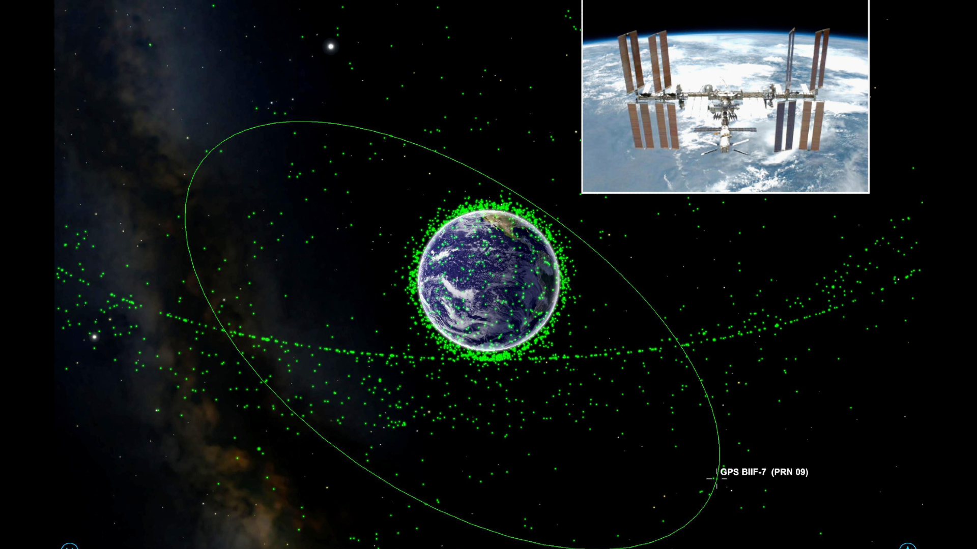
Orbit View displays a zoomable 3D rendered model of the Earth surrounded by green dots for orbiting satellites. Tap a dot to show that satellite’s orbit and name. By default, the display will be fairly cluttered. In the Settings menu, under Satellites Shown, you can decide which classes of satellites to include. As a fun exercise, enable just the geostationary satellites to see how their distant orbits contrast with low Earth orbit satellites such as the ISS and the Hubble Space Telescope. You can also opt to display all satellite names, major cities, and show only the selected satellite.
In Satellite View you see a 3D rendering of major satellites and travel in space alongside them. By swiping your finger you can view the satellite from any angle and watch it transition from fully lit to shadowed as it orbits Earth. Launching VR mode allows you to fly around the satellite by moving your device while viewing it immersively.
The fourth mode, Ground View, is a feature found in most satellite tracking apps. It displays a top-down view of the selected satellite as it flies over Earth. The orbital track is displayed, along with a «you are here» indicator. In any of the modes, tapping the Centre icon will bring the selected satellite front and center.
ISS Detector
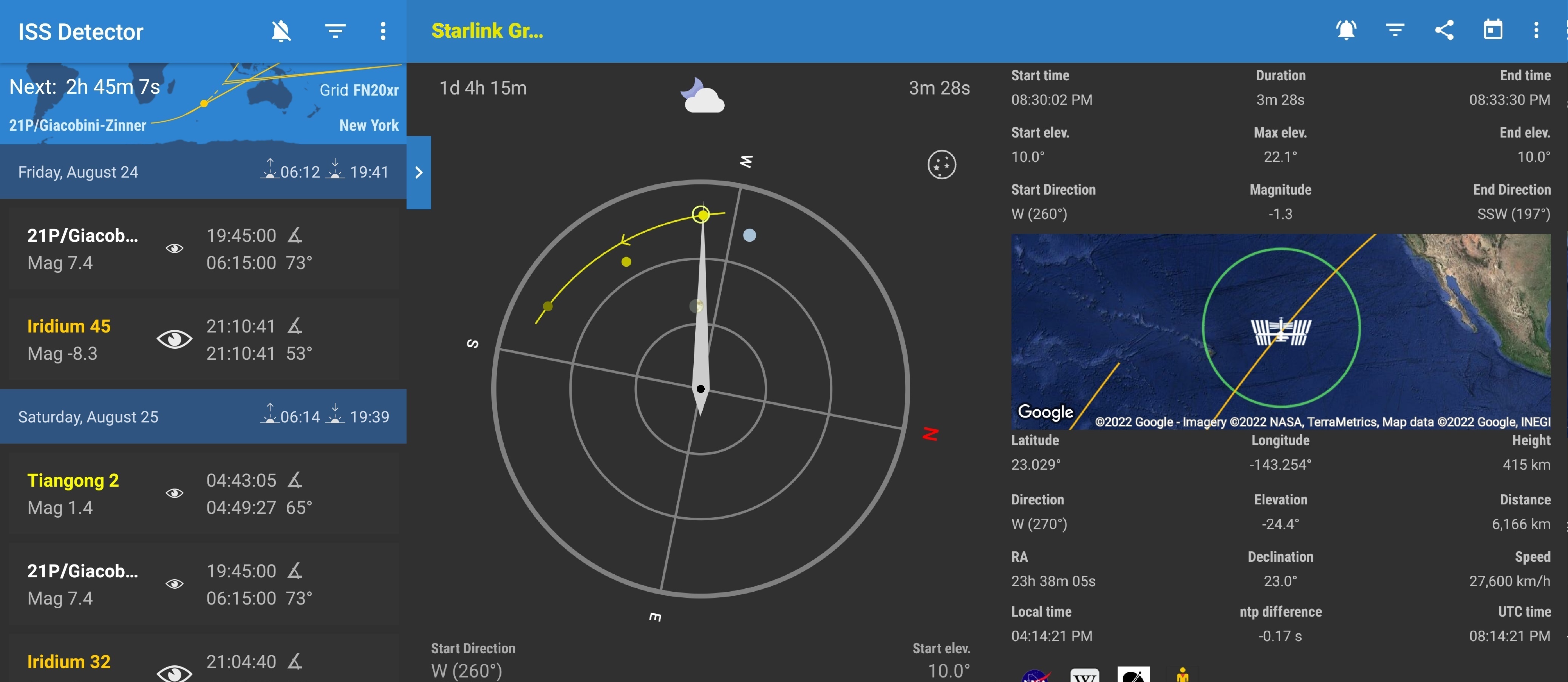
The free ISS Detector app by RunaR is a personal favorite. The free version for Android and iOS tracks the ISS. An inexpensive extension pack will track additional a great many satellites, planets, and even comets.
The app’s user interface is very easy to understand. The main page lists upcoming events ordered soonest to latest and distinguishes the ISS, Starlink, famous satellites, comets, and other objects’ labels by color codes. For each pass, an «eye» icon is sized to represent the quality of the pass. The local time of the start and end of the satellite pass, as well as the angle above the horizon at which it will occur, completes the information provided. The app can link to your local weather forecast, grade the probability of the pass quality, and show the weather as a symbol. Even the sunrise and sunset times are available at a glance.
If you are only interested in certain types of events, use the filters on the Events page, and enable alerts for only the events you want to observe. Within each object category, you can set limits on the minimum elevation (if your horizon is obstructed) and the minimum brightness, toggle all-day or night-only passes, and even set the quality threshold. You can manually refresh the orbital data anytime. The time until the next event is indicated prominently.
On the phone version of ISS Detector, selecting an event brings up a trio of tabs labeled Radar, Details, and Live Video. Tapping a panel reveals it. Swiping left and right switches between panes. The Details pane shows the numerical parameters for the pass, including the current location above Earth and in the sky. A map of Earth shows the orbit track and current location. A double-tap enlarges the map for pan, pinch and zoom exploring.
The handy Radar pane makes ISS Detector shine. It displays a dynamic compass and tilt indicator to allow you to align your device with the satellite in real-time, indicating clearly where in the sky to look. A solid blue arc shows the track of the satellite and the point of maximum height. You can rehearse a pass at any time to see how it will cross your sky. During a live event, the compass needle follows the satellite, allowing you to track it by moving your device. In both cases, the moon and the planets are displayed to help orient you. Hold a finger on the pane to display pass timings and planet labels. You can toggle between compass mode and a whole sky star map, where the object’s track and direction through the stars are nicely indicated. The app will guide you to any visible comets in the same manner, if you’ve purchased that upgrade.
The Live Video pane allows you to watch the video being streamed by NASA from the ISS, in either HD or SD mode; but an internet connection is required. On a tablet’s larger display, the pass list, Radar, and Detail panes are shown at the same time — but the live feed option is unavailable.
The ISS Detector app will notify you of impending passes, from 1 minute to 1 hour in advance, and offer silent periods. You can also add any pass to your personal calendar. The app can link to the IP address of a rotator, to allow a ham antenna or a telescope to track a satellite — but I haven’t tried out that feature. It sounds like fun!
Sky charting apps track satellites, too
Users of popular sky charting apps already have satellite predicting tools at hand, albeit with a bit less functionality. The free Stellarium desktop utility has a plug-in called Satellites that will display their locations in the sky and permit searches for names — but it does not provide pass predictions.
The free Stellarium Mobile app for Android and the paid Stellarium Plus for iOS, both produced by Stellarium Labs, offers plenty of information about satellites, and terrific tools for predicting them and seeing them. Using the default settings, only one or two satellites might appear on the displayed sky. But long-press the labels menu and run the satellites slider to the right to reveal everything passing overhead. Tap on a satellite to select it and then swipe up to expand its information panel. There you can review data about the object and read its Wikipedia entry. Tapping the «3D» label will place you in space beside the object and allow you to fly around it with finger swipes.
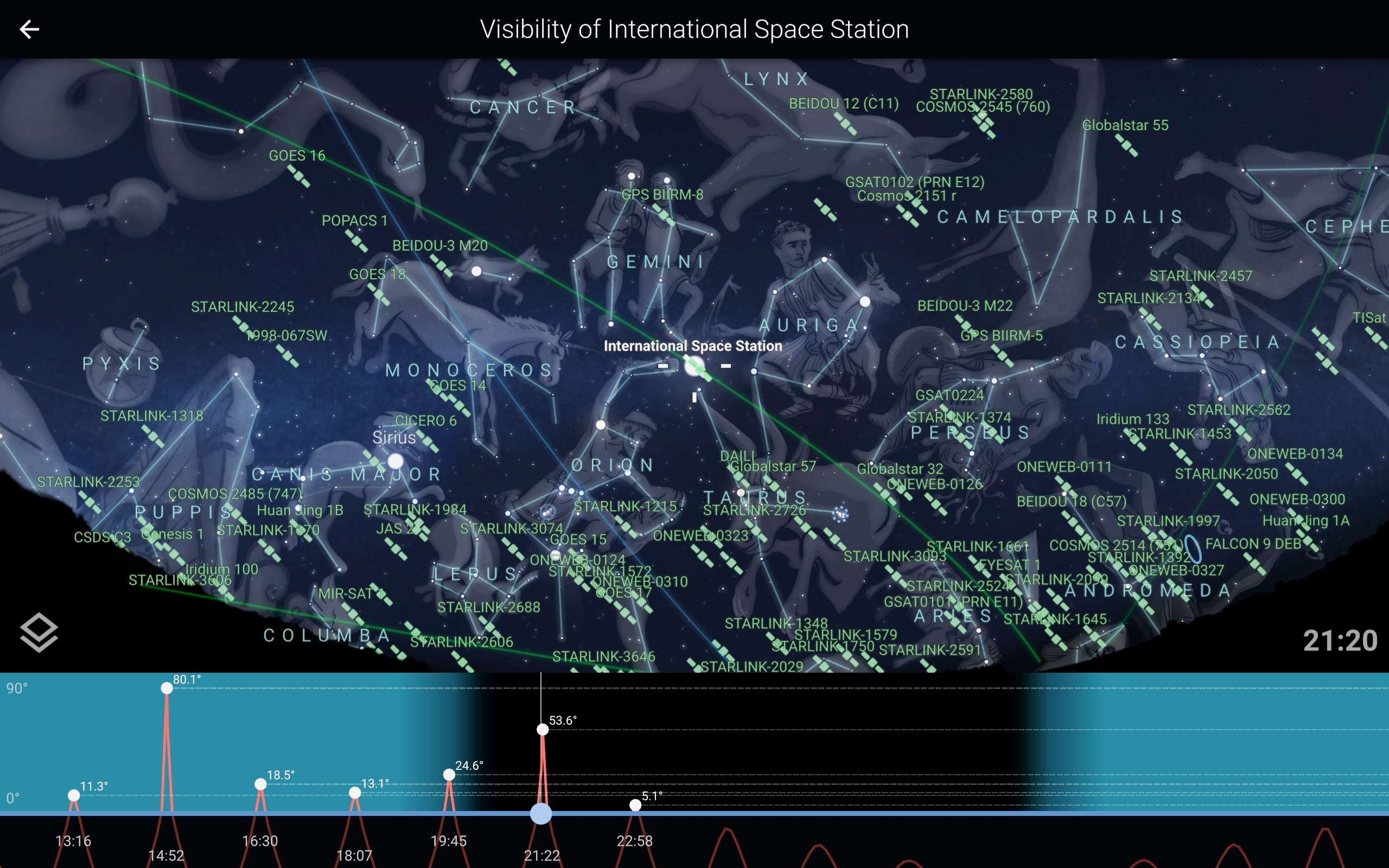
Tap the button labeled «Visibility» to summon a graph of that satellite’s elevation during today’s 24 hour period. Higher elevations suggest longer, brighter passes. Moving a slider at the bottom of the graph alters the sky to that time, allowing you to review or preview the satellite’s path through the stars. Tapping a pass does the same thing. Tilting the phone up to the sky will trigger compass mode, showing you the annotated Stellarium sky in front of the real thing. Center the satellite (or any object, for that matter) in the display and the real object will be in front of you. Tapping the Locate button in the toolbar will summon an arrow to show you where to point your phone.
The various versions of the SkySafari app each allow you to search for individual satellites or select from a list called Current Satellites that can be sorted by brightness, height, rise time, and more. By default, satellites aren’t displayed in the sky, but the current ones can be plotted as small blue circles on the sky by tapping the Actions & Settings gear icon and then the Highlight Objects checkbox.
Tapping a satellite in a list, or its symbol on the sky calls up its information page. Scroll down to find a chronological list of passes. Both Daylight — Not Visible and Night Passes — Visible are provided. For each pass, the date and rise, culminate, and set times are given, including the direction and elevation for each event. Tap the small clock icon beside an event to show at that time. You can also tap the Center icon to show a satellite’s location in the sky now. The Orbit icon will park you in space beside a 3D model of the satellite. The basic versions of SkySafari limit the number of satellites to about 125. The Plus and Pro versions track almost 2,000 of them.
Good luck with your satellite hunting pursuits, and keep looking up!
Editor’s note: Chris Vaughan is an astronomy public outreach and education specialist at AstroGeo, an award-winning member of the Royal Astronomical Society of Canada, and an operator of the historic 74″ (1.88-meter) David Dunlap Observatory telescope. In 2021, he and John A. Read published 110 Things to See with a Telescope. You can reach him via email, and follow him on Twitter as @astrogeoguy, Instagram, and Facebook.
Follow us @Spacedotcom, Facebook and Google+.
Join our Space Forums to keep talking space on the latest missions, night sky and more! And if you have a news tip, correction or comment, let us know at: community@space.com.
Get breaking space news and the latest updates on rocket launches, skywatching events and more!
Chris Vaughan, aka @astrogeoguy, is an award-winning astronomer and Earth scientist with Astrogeo.ca, based near Toronto, Canada. He is a member of the Royal Astronomical Society of Canada and hosts their Insider’s Guide to the Galaxy webcasts on YouTube. An avid visual astronomer, Chris operates the historic 74˝ telescope at the David Dunlap Observatory. He frequently organizes local star parties and solar astronomy sessions, and regularly delivers presentations about astronomy and Earth and planetary science, to students and the public in his Digital Starlab portable planetarium. His weekly Astronomy Skylights blog at www.AstroGeo.ca is enjoyed by readers worldwide. He is a regular contributor to SkyNews magazine, writes the monthly Night Sky Calendar for Space.com in cooperation with Simulation Curriculum, the creators of Starry Night and SkySafari, and content for several popular astronomy apps. His book «110 Things to See with a Telescope», was released in 2021.
Most Popular
В 2005 году россиянам стала доступна услуга спутникового телевидения от ЗАО «Национальная спутниковая компания Триколор ТВ». Сегодня вещание телеканалов ведется с трех искусственных спутников, находящихся на земной орбите и транслирующих широкополосный сигнал на большую часть Российской Федерации.
Содержание
- Немного информации о спутнике Триколор-TB
- ЗАО Национальная спутниковая компания Триколор-ТВ
- Как направить телеантенну на спутник
- Установка угла наклона спутниковой тарелки
- Установка угла поворота антенны по азимуту
- Установка угла поворота конвертера спутниковой тарелки
- Программа для определения направления спутника Триколор
- Механическая версия
- Электронный вариант
- Определение с помощью камеры
- Двухспутниковое телевидение «Триколор-ТВ» на 2 телевизора
Немного информации о спутнике Триколор-TB
Первое, что нужно знать, прежде чем приобрести стартовый комплект цифрового телевещания — какой спутник у Триколор ТВ, его частоту и возможность получения сигнала в этом регионе. Как бы ни обширно было покрытие оператора, некоторые регионы остаются неохваченными.
Сигнал провайдера передается с трех станций. Названия спутников Триколор:
- Eutelsat-36С. Оборудован 70 транспондерами и 5 высокомощными лучами. Последние способны перенацеливаться.
- Eutelsat-36В. Оснащен 27 транспондерами, действующими в зоне фиксированного луча.
- Express-АТ1. Спутник имеет 70 транспондеров и 5 мощных направленных лучей.
То, на какой спутник настраивать Триколор, зависит от региона Российской Федерации. Первые две станции вещают телесигнал на европейскую часть страны. Населенные пункты Урала и Сибири, а также территория Дальнего Востока попадают под охват отечественного Экспресс-АТ1.
Некоторые пользователи думают, что спутники принимают сигналы телевидения откуда-то из космоса. Но спутники лишь рассеивают радиоволны, принятые от наземной телевышки. Цифровой формат сигнала позволяет передавать изображение и звук высокого качества.
Принимающее оборудование на Земле делится на два типа:
- Офсетные телеантенны. Такие приборы сегодня номер один по популярности среди городских жителей. Конструкция тарелки позволяет устанавливать ее как на крыше, так и на стене дома, а установленный конвертер не перекрывается держателями.
- Прямофокусные. Конвертер на таких устройствах расположен в центре с помощью специальных креплений. Такие приборы достаточно громоздкие и тяжелые, поэтому находят применение в частных домах, где нет проблем с размещением.
ЗАО Национальная спутниковая компания Триколор-ТВ
Закрытое акционерное общество «Национальная спутниковая компания Триколор ТВ» — один из ведущих игроков на поле цифрового ТВ и интернета. В пользу компании сделали свой выбор более 12 млн российских домовладельцев. В процентном соотношении это треть от всего телекоммуникационного рынка страны. 70% пользователей используют доступ к HD-каналам, а некоторое время назад Триколор ТВ предложил клиентам новую услугу — пакет, в который входят телеканалы со стандартом вещания Ultra HD. Сервис дает возможность просматривать видео в 4К формате, но требует специального оборудования.
Как направить телеантенну на спутник
Чистое качество без назойливых квадратиков на экране зависит от ряда факторов. Самый главный из них — направление антенны Триколор на спутник. Все космическое оборудование, эксплуатируемое провайдером, находится на орбите над экватором. Российская территория, вне зависимости от региона, лежит севернее станций, так что в любом городе тарелка должна смотреть в южном направлении. Остальные параметры зависят от точки установки.
Самый простой способ узнать способ расположения антенны — произвести расчеты на онлайн-ресурсе Satellite Antenna Alignment. Для получения точного результата понадобится наименование спутника и город нахождения оборудования.
Данные нужно ввести в специальные поля, после чего система производит вычисления и выдает ряд показателей:
- азимут;
- градус угла места;
- поляризацию;
- время, когда Солнце и спутник находится на одной линии;
- нужный угол поворота конвертера;
- расстояние от точки установки до спутника.
Установка угла наклона спутниковой тарелки
Рассчитать угол места можно несколькими методами. Самый элементарный — воспользоваться мобильным приложением, определяющим координаты местности по геопозиционированию.
Несколько сложнее, но интереснее выставить антенну в зависимости от Солнца. Способ применяют для устройств офсетного типа. Для наладки понадобится знать время, когда небесное светило встанет в одну линию со спутником. Для точного положения антенны нужно поймать солнечный зайчик, отраженный от зеркала телеантенны, на конвертер. Метод альтернативный, однако по отзывам пользователей действенный.
Важно: Настраивать телеантенну по Солнцу можно только в ясную погоду. Тарелку не должны затенять соседние здания, столбы и деревья. Облегчат ситуацию кусочки фольги, наклеенные на зеркало тарелки. Так солнечный зайчик будет более четким.
Легче всего определиться с углом наклона тарелки абонентам, соседи которых уже используют услуги провайдера. Для этого достаточно повторить положение соседского устройства и чуть подрегулировать его.
Профессиональные мастера применяют специальный прибор, позволяющий определить параметры с максимальной точностью.
Люди с инженерным складом ума могут самостоятельно рассчитать угол наклона дефлектора, взяв за основу координаты спутника, точки установки и показатель магнитного склонения. Чем ближе местность к югу, тем больше зеркало антенны будет задрано вверх, в направлении спутниковой орбиты. И наоборот, — чем севернее местность, тем ниже будет опущен дефлектор.
Установка угла поворота антенны по азимуту
Азимут показывает географическую ориентацию принимающего устройства относительно горизонтальной плоскости. Для настройки по азимуту можно воспользоваться компасом или все тем же мобильным приложением, либо выставить телеантенну вручную. Для этого нужно менять положение зеркала каждые несколько секунду до получения нужного уровня сигнала на экране ТВ.
Установка угла поворота конвертера спутниковой тарелки
Бывает, что антенна установлена согласно всем расчетам, а сигнала Триколор ТВ как не было, так и нет, либо он очень слабый. Тогда нужно искать причину в конвертере, вернее, в его некорректной настройке.
Орбита, по которой двигаются телеспутники, представляет собой дугу, по отношению к которой конвертер должен быть развернут. Угол поворота передатчика рассчитывается в том же приложении, где и остальные показатели.
Программа для определения направления спутника Триколор
Профессиональные установщики спутникового оборудования используют специальный прибор для точной настройки, который называется SatFinder. Сервис доступен в нескольких модификациях.
Механическая версия
Механический прибор. Для его применения понадобится коаксиальный кабель длиной около 18-20 см с коннекторами на концах.
Алгоритм использования следующий:
- Отключить от конвертера провод, ведущий к ресиверу и переключить его в гнездо ТО REC.
- В освободившийся разъем подключить короткий кабель и соединить его с SatFinder.
- Включить устройство, дождаться, пока оно загрузится, и выставить стрелку на шкале на отметке 5.
- Включить ресивер, дождаться загрузки.
- Медленно поворачивать антенну. О появлении радиоволны сообщит звуковой сигнал.
- Приступить к точным настройкам, отслеживая качество и мощность приема на экране ТВ.
- Отключить прибор, присоединить шнур, идущий от ресивера, обратно.
Электронный вариант
Электронная версия SatFinder сегодня используется наиболее часто и очень комфортна для установщика. Аппарат действует полностью автоматически.
Схема следующая:
- Прибор подключается в максимальной близости к телеантенне.
- В меню настроек прибора выбрать спутник, подключение ресивера. Цифровая приставка включается автоматически через SatFinder. О том, что оборудование работает корректно, говорят два горящих индикатора.
- Медленно двигать тарелку, дожидаясь включения максимального количества индикаторов. Улавливанию сигнала сопровождается звуками различной интенсивности. Чем громче звук, тем сильнее уровень сигнала.
- После окончания настройки отсоединить прибор.
Определение с помощью камеры
Для самостоятельной установки спутникового оборудования разработчики предлагают мобильную версию SatFinder, которая устанавливается даже на самые простые телефоны. Нужна лишь камера и система навигации.
Приложение бесплатно для пользователя, схема понятна:
- Войти в программу.
- Включить камеру.
- Активировать GPS.
- Найти спутник.
- Настроить телеантенну по предложенным параметрам.
Двухспутниковое телевидение «Триколор-ТВ» на 2 телевизора
Два телевизора в одной квартире – это давно уже не роскошь, а необходимость. Установив спутниковую тарелку, абоненты Триколор хотят иметь доступ к телеканалам с любого телеприемника. Для этого пользователи устанавливают разделители, направляя сигнал через кабель к каждому устройству.
Такой вариант разделения вещания оправдывает себя, только если используется мощный коаксиальный провод с хорошими характеристиками. Иначе качество приема заметно снижается.
Спутниковый оператор предлагает бюджетное решение проблемы — систему ресивер-клиент. Компактная дополнительная приставка присоединяется к основному устройству и передает на второй ТВ сигнал без утраты качества.
ЗАО «Триколор» постоянно двигается вперед, открывая клиентам все новые и новые возможности спутникового телевидения. На официальном сайте оператора всегда можно найти карту цифрового покрытия, существенно облегчающую процесс настраивания телеантенны, а также попросить помощи в затруднительных вопросах, связанных с наладкой аппаратуры.
Возможное место для ваших реклам! Приветствуется серьезный рекламодатель! Пишите на e-mail договоримся…
Спутниковое телевидение полностью зависит от спутников.
Но может возникнуть правомерный вопрос, где они спутники, как их найти на моем спутниковым ресивере?
Надо понимать что все имеющийся спутники, как бы это странно не показалось, дружно стоят на своих орбитах.
Можно сказать и немного поинтересней, как вкопанные! И все по одной причине, они крутятся вместе с нашей землей.
Потому спутниковое телевидение имеет место у тебя дома и один раз настроивший антенну, можешь любоваться телепередачами.
Однако, не все так радужно, как может показаться!
Если не получается настроить сателлит антенну, то может иметь место причина, от вас не зависящая. Если коротко то Ваша местность или Ваша локация, в которой производится установка сателлит антенны, не попадает в зону покрытия данного спутника.
Если дошло до понимания ситуация, что… ну не как не попадает, то надо будет определиться с желаниями и реальными возможностями по месту проживания.
Для начала вы должны определиться, на какой все-таки спутник вы будете настраивать вашу спутниковую тарелку, и какие частоты ему принадлежат.
Как узнать какие вообще есть спутники и как смотреть спутниковое телевидение?
Для этой цели я пользуюсь хорошей программой… Satellite Transponders, которая раз в месяц обновляет информацию по спутникам.
В этой программе вы найдете нужный вам спутник с названиями телевизионных каналов, радиостанциями, с интернет провайдерами, а также узнаете диапазоны вещания с транспондерными частотами.
Далее, выбрав спутник, вы должны узнать, попадает ли ваша местность, в которой производите установку тарелки, в зону покрытия данного спутника.
Карты с зонами покрытия спутников можно посмотреть на сайте www.lyngsat-maps.com. На рисунке ниже изображен пример карты с зоной покрытия для спутника Hot Bird 7a на 13.0°E

Спутники
Спутник |
Градус |
Адрес на Lyngsat |
| Amos 1/2 |
4W |
lyngsat.com/amos.html |
| Intelsat 10-02 Thor 2/3 * |
1W |
lyngsat.com/1west.html |
| Sirius 2/3 Astra 1C* |
4.8E |
lyngsat.com/sirius.html |
| Eutelsat W3A |
7E |
lyngsat.com/ew3a.html |
| Eurobird 9A |
9E |
lyngsat.com/eb9a.html |
| Eutelsat W1 |
10E |
lyngsat.com/ew1.html |
| HotBird |
13E |
lyngsat.com/hotbird.html |
| Eutelsat W2 |
16E |
lyngsat.com/ew2.html |
| Astra 1 |
19.2E |
lyngsat.com/astra19.html |
| Eutelsat W6 |
21.5Е |
lyngsat.com/ew6.html |
| Kopernikus (Astra 2) Eurobird 1 * |
28.2E |
lyngsat.com/28east.html |
| Eutelsat W4 |
36E |
lyngsat.com/36east.html |
| Hellas Sat 2 |
39E |
lyngsat.com/hellas2.html |
| Express AM1 |
40E |
lyngsat.com/eam1.html |
| Turksat 1C/2А |
42Е |
lyngsat.com/turk42.html |
| Yamal 202 |
49E |
lyngsat.com/yamal202.html |
| Express AM22 |
53E |
lyngsat.com/eam22.html |
| Intelsat 904 |
60E |
lyngsat.com/intel904.html |
| Intelsat 4 |
72E |
lyngsat.com/intel4.html |
| ABS 1 |
75E |
lyngsat.com/abs1.html |
| Express AM2 |
80E |
lyngsat.com/eam2.html |
Удачного просмотра и будет вам друг, спутниковое телевидение!
Спутниковый указатель это мощный инструмент, с помощью которого вы легко установите спутниковую тарелку. Каждую неделю мы добавляем в приложение новые спутники и функции.
Установить телевизор спутниковую тарелку теперь проще простого.
Направьте устройство на небо и в режиме дополненной реальности вы увидите геостационарные спутники, вращающиеся вокруг земли. У вас будет доступ к более чем 200 спутникам и возможность быстро найти нужный вам.
Как только вы выберете спутник, вы сможете ознакомиться с нужной вам информацией, например, географической зоной, долготой, частотами, азимутом, высотой и углами поляризации, которые будут рассчитаны на основании вашего местоположения.
Вы сможете затем «зафиксировать» этот спутник с помощью 4-шагового инструмента выравнивания, что поможет легко установить антенну (доступно только в PRO версии).
Особенности:
• Добавленная реальность: нацеливайте спутники непосредственно на свой дисплей
• Азимут, углы высоты и поляризации, рассчитанные для вашей позиции
• Более 200 спутников, упомянутых в приложении
• Возможность поиска, чтобы быстро находить нужный спутник
• Еженедельные обновления базы данных (ежедневные для PRO пользователей)
• Добавление спутников вручную (PRO пользователи)
• 4-шаговый инструмент выравнивания для быстрой настройки антенны (PRO пользователи)
Спасибо, что пользуетесь Satellite Pointer. Присылайте нам свои отзывы на contact@satellitepointer.com и мы ответим как можно скорее. Если вам нравится Satellite Pointer, будем рады 5 звездам и приятным комментариям в App Store.
Что нового
8 июн. 2018 г.
Версия 4.3.5
Приложение было обновлено компанией Apple, чтобы в нем отображался значок приложения Apple Watch.
Спасибо за использование Спутниковый указатель!
Представляем новые функции этой версии:
— Новый инструмент 4-шагового выравнивания для быстрой настройки антенны
— Новый дисплей дополненной реальности
— Обновленная база данных спутника с обновлениями еженедельно (ежедневно для PRO пользователей)
— Улучшенная производительность
— Обновленный дизайн для iOS 11
— Небольшие исправления
Мы надеемся, что вам понравится Satellite Pointer. Обязательно присылайте нам свои отзывы на contact@satellitepointer.com и ставьте нам 5 звезд в App Store.
Оценки и отзывы
Как найти нужный спутник при установке тарелки.
Единственное приложение для iPhone работающее стабильно и корректно. Нет ничего лишнего, все что нужно в данном преложении. Один раз купил и пользуюсь уже пару лет без всяких проблем!
Самое главное, сто сразу видно если препятствие на пути сигнала. Спасибо разработчику. Особо приятно, что приложение на русском языке!
Не работает,верните деньги!!!!
Не работает
Обман
Постоянно предлагалось обновить программу, при обновлении (оказавшемся платным) с меня списали сначала указанную сумму, после этого снялась повторно ещё большая сумма. Требую вернуть средства.
Конфиденциальность приложения
Разработчик TouchDown Apps указал, что в соответствии с политикой конфиденциальности приложения данные могут обрабатываться так, как описано ниже. Подробные сведения доступны в политике конфиденциальности разработчика.
Данные, используемые для отслеживания информации
Следующие данные могут использоваться для отслеживания информации о пользователе в приложениях и на сайтах, принадлежащих другим компаниям:
-
Геопозиция
-
Идентификаторы
-
Данные об использовании
Не связанные
с пользователем данные
Может вестись сбор следующих данных, которые не связаны с личностью пользователя:
-
Геопозиция
-
Идентификаторы
-
Данные об использовании
-
Диагностика
Конфиденциальные данные могут использоваться по-разному в зависимости от вашего возраста, задействованных функций или других факторов. Подробнее
Информация
- Провайдер
- TouchDown Apps
- Размер
- 53,4 МБ
- Категория
-
Утилиты
- Совместимость
-
- iPhone
- Требуется iOS 10.0 или новее.
- iPad
- Требуется iPadOS 10.0 или новее.
- iPod touch
- Требуется iOS 10.0 или новее.
- Mac
- Требуется macOS 11.0 или новее и компьютер Mac с чипом Apple M1 или новее.
- Языки
-
русский, английский, арабский, испанский, итальянский, корейский, немецкий, португальский, турецкий, упрощенный китайский, французский
- Возраст
- 4+
- Copyright
- © TouchDown Apps SARL
- Цена
- Бесплатно
-
Сайт разработчика
-
Поддержка приложения
-
Политика конфиденциальности
-
Сайт разработчика
-
Поддержка приложения
-
Политика конфиденциальности