Расстояние между двумя координатами
Онлайн калькулятор рассчитывает расстояние между двумя географическими координатами.
Инструкция по использованию калькулятора
Широту и долготу двух точек, между которыми необходимо найти расстояние, следует указывать в градусах в виде десятичной дроби.
Например, расстояние между Москвой (55.75059; 37.61777) и Киевом (50.44952; 30.52537) составляет 755 километров.
Южная широта и западная долгота задаются отрицательной величиной от 0° до -90° и от 0° до -180° соответственно.
Поделиться страницей в социальных сетях:
С помощью карты можно определять расстояние между точками на земной поверхности, но точность таких вычислений невысока.
Ситуация относительно проста, если точки лежат на одном меридиане. Все меридианы имеют одинаковую длину. Можно подсчитать, что одному градусу широты соответствует примерно 111,3 км реальной длины. Поэтому надо найти разницу в долготе между точками и умножить ее на 111,3 км. Например, если точка А находится на северной широте 50°, а Б располагается на северной широте 32°, и при этом у них совпадает долгота, то расстояние между ними составит.
111,3х(50° – 32°) = 111,3х16 = 1780,8 км
Ситуация меняется, когда одна точка имеет северную, а другая – южную широту. В этом случае широты уже надо складывать. Так, если бы точка Б из предыдущего примера располагалась бы на южной широте 32°, то расстояние от А до Б составило бы:
111,3х(50° + 32°) = 111,3х82 = 9126,6 км
Ситуация усложняется, когда точки находятся на разных меридианах, но на одной параллели. Если у обеих точек долгота западная (или, наоборот, восточная), то сначала надо найти разницу их долгот. Если же одна точка имеет восточную, а другая западную долготу, то их надо суммировать. Далее результат надо умножить на длину 1° параллели. Эта длина у параллелей различна и зависит от их широты. Можно воспользоваться таблицей ниже:
| Широта параллели | Длина ее дуги величиной в 1° |
|---|---|
| 0° | 111,3 |
| 5° | 110,9 |
| 10° | 109,6 |
| 15° | 107,6 |
| 20° | 104,6 |
| 25° | 102,1 |
| 30° | 96,5 |
| 35° | 91,3 |
| 40° | 85,4 |
| 45° | 78,8 |
| 50° | 71,7 |
| 55° | 64,0 |
| 60° | 55,8 |
| 65° | 47,2 |
| 70° | 38,2 |
| 75° | 28,9 |
| 80° | 19,4 |
| 85° | 9,7 |
| 90° | 0 |
Например, нужно найти расстояние между точками, имеющими координаты:
А – 60° с. ш, 39° з. д.
Б – 60° с. ш, 25° з. д.
Широты у них одинаковы, поэтому смотрим на долготу. Она у обеих точек западная, поэтому надо найти их разницу:
39° – 25° = 14°
Полученный результат надо умножить на длину 1° параллели, широта которой составляет 60°. По табличке определяем, что на широте 60° дуга в 1° имеет длину 55,8 км. Перемножаем два числа:
14°х 55,8 км = 781,2 км
Список использованных источников
• https://www.yaklass.ru/p/geografiya/5-klass/izobrazheniia-zemnoi-poverkhnosti-i-ikh-ispolzovanie-131512/geograficheskie-koordinaty-161116/re-d77ff3cc-0858-4fd8-aabd-69f1fdffb41d
• https://interneturok.ru/lesson/geografy/5-klass/plan-i-karta/gradusnaya-setka-geograficheskaya-dolgota-i-shirota

Гугломаг
Спрашивай! Не стесняйся!
Задать вопрос
Не все нашли? Используйте поиск по сайту
From Wikipedia, the free encyclopedia

Geographical distance or geodetic distance is the distance measured along the surface of the earth. The formulae in this article calculate distances between points which are defined by geographical coordinates in terms of latitude and longitude. This distance is an element in solving the second (inverse) geodetic problem.
Introduction[edit]
Calculating the distance between geographical coordinates is based on some level of abstraction; it does not provide an exact distance, which is unattainable if one attempted to account for every irregularity in the surface of the earth.[1] Common abstractions for the surface between two geographic points are:
- Flat surface;
- Spherical surface;
- Ellipsoidal surface.
All abstractions above ignore changes in elevation. Calculation of distances which account for changes in elevation relative to the idealized surface are not discussed in this article.
Nomenclature[edit]
Distance,  is calculated between two points,
  and
and  . The geographical coordinates of the two points, as (latitude, longitude) pairs, are
  and
and  respectively. Which of the two points is designated as is not important for the calculation of distance.
Latitude and longitude coordinates on maps are usually expressed in degrees. In the given forms of the formulae below, one or more values must be expressed in the specified units to obtain the correct result. Where geographic coordinates are used as the argument of a trigonometric function, the values may be expressed in any angular units compatible with the method used to determine the value of the trigonometric function. Many electronic calculators allow calculations of trigonometric functions in either degrees or radians. The calculator mode must be compatible with the units used for geometric coordinates.
Differences in latitude and longitude are labeled and calculated as follows:

It is not important whether the result is positive or negative when used in the formulae below.
«Mean latitude» is labeled and calculated as follows:

Colatitude is labeled and calculated as follows:
- For latitudes expressed in radians:
- For latitudes expressed in degrees:


Unless specified otherwise, the radius of the earth for the calculations below is:
 = 6,371.009 kilometers = 3,958.761 statute miles = 3,440.069 nautical miles.

 = Distance between the two points, as measured along the surface of the earth and in the same units as the value used for radius unless specified otherwise.
Singularities and discontinuity of latitude/longitude[edit]
Longitude has singularities at the Poles (longitude is undefined) and a discontinuity at the ±180° meridian. Also, planar projections of the circles of constant latitude are highly curved near the Poles. Hence, the above equations for delta latitude/longitude ( ,
,  ) and mean latitude (
 ) may not give the expected answer for positions near the Poles or the ±180° meridian. Consider e.g. the value of («east displacement») when
  and
and  are on either side of the ±180° meridian, or the value of («mean latitude») for the two positions (
 =89°, =45°) and (
 =89°, =−135°).
If a calculation based on latitude/longitude should be valid for all Earth positions, it should be verified that the discontinuity and the Poles are handled correctly. Another solution is to use n-vector instead of latitude/longitude, since this representation does not have discontinuities or singularities.
Flat-surface formulae[edit]
A planar approximation for the surface of the earth may be useful over small distances. The accuracy of distance calculations using this approximation become increasingly inaccurate as:
- The separation between the points becomes greater;
- A point becomes closer to a geographic pole.
The shortest distance between two points in plane is a straight line. The Pythagorean theorem is used to calculate the distance between points in a plane.
Even over short distances, the accuracy of geographic distance calculations which assume a flat Earth depend on the method by which the latitude and longitude coordinates have been projected onto the plane. The projection of latitude and longitude coordinates onto a plane is the realm of cartography.
The formulae presented in this section provide varying degrees of accuracy.
Spherical Earth projected to a plane[edit]
This formula takes into account the variation in distance between meridians with latitude:
- where:
- and are in radians;
- must be in units compatible with the method used for determining


- To convert latitude or longitude to radians use

This approximation is very fast and produces fairly accurate result for small distances[citation needed]. Also, when ordering locations by distance, such as in a database query, it is faster to order by squared distance, eliminating the need for computing the square root.
Ellipsoidal Earth projected to a plane[edit]
The FCC prescribes the following formulae for distances not exceeding 475 kilometres (295 mi):[2]
- where
- = Distance in kilometers;
- and are in degrees;
- must be in units compatible with the method used for determining


- Where and are in units of kilometers per degree. It may be interesting to note that:
- = kilometers per degree of latitude difference;
- = kilometers per degree of longitude difference;
- where and are the meridional and its perpendicular, or «normal«, radii of curvature (the expressions in the FCC formula are derived from the binomial series expansion form of and , set to the Clarke 1866 reference ellipsoid).


For a more computationally efficient implementation of the formula above, multiple applications of cosine can be replaced with a single application and use of recurrence relation for Chebyshev polynomials.
Polar coordinate flat-Earth formula[edit]
- where the colatitude values are in radians. For a latitude measured in degrees, the colatitude in radians may be calculated as follows:


Spherical-surface formulae[edit]
If one is willing to accept a possible error of 0.5%, one can use formulas of spherical trigonometry on the sphere that best approximates the surface of the earth.
The shortest distance along the surface of a sphere between two points on the surface is along the great-circle which contains the two points.
The great-circle distance article gives the formula for calculating the distance along a great-circle on a sphere about the size of the Earth. That article includes an example of the calculation.
Tunnel distance[edit]
A tunnel between points on Earth is defined by a line through three-dimensional space between the points of interest.
The great circle chord length may be calculated as follows for the corresponding unit sphere:

The tunnel distance between points on the surface of a spherical Earth is
 . For short distances (
 ), this underestimates the great circle distance by
  .
.
Ellipsoidal-surface formulae[edit]
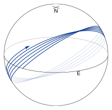
Geodesic on an oblate ellipsoid
An ellipsoid approximates the surface of the earth much better than a
sphere or a flat surface does. The shortest distance along the surface
of an ellipsoid between two points on the surface is along the
geodesic. Geodesics follow more complicated paths than great
circles and in particular, they usually don’t return to their starting
positions after one circuit of the earth. This is illustrated in the
figure on the right where f is taken to be 1/50 to accentuate the
effect. Finding the geodesic between two points on the earth, the
so-called inverse geodetic problem, was the focus of many
mathematicians and geodesists over the course of the 18th and 19th
centuries with major contributions by
Clairaut,[3]
Legendre,[4]
Bessel,[5]
and Helmert.[6]
Rapp[7]
provides a good summary of this work.
Methods for computing the geodesic distance are widely available in
geographical information systems, software libraries, standalone
utilities, and online tools. The most widely used algorithm is by
Vincenty,[8]
who uses a series which is accurate to third order in the flattening of
the ellipsoid, i.e., about 0.5 mm; however, the algorithm fails to
converge for points that are nearly antipodal. (For
details, see Vincenty’s formulae.) This defect is cured in the
algorithm given by
Karney,[9]
who employs series which are accurate to sixth order in the flattening.
This results in an algorithm which is accurate to full double precision
and which converges for arbitrary pairs of points on the earth. This
algorithm is implemented in GeographicLib.[10]
The exact methods above are feasible when carrying out calculations on a
computer. They are intended to give millimeter accuracy on lines of any
length; one can use simpler formulas if one doesn’t need millimeter
accuracy, or if one does need millimeter accuracy but the line is short.
Rapp,[11] Chap. 6, describes the Puissant method,
the Gauss mid-latitude method, and the Bowring method.[12]
Lambert’s formula for long lines[edit]
Lambert’s formulae[13]
give accuracy on the order of 10 meters over thousands of kilometers. First convert the latitudes  ,
,  of the two points to reduced latitudes
  ,
, 

where  is the flattening.
Then calculate the central angle  in radians between two points
  and
and  on a sphere using the Great-circle distance method (law of cosines or haversine formula), with longitudes
  and
and  being the same on the sphere as on the spheroid.


where  is the equatorial radius of the chosen spheroid.
On the GRS 80 spheroid Lambert’s formula is off by
- 0 North 0 West to 40 North 120 West, 12.6 meters
- 0N 0W to 40N 60W, 6.6 meters
- 40N 0W to 40N 60W, 0.85 meter
Bowring’s method for short lines[edit]
Bowring maps the points to a sphere of radius R′, with latitude and longitude represented as φ′ and λ′. Define

where the second eccentricity squared is

The spherical radius is

(The Gaussian curvature of the ellipsoid at φ1 is 1/R′2.)
The spherical coordinates are given by
![begin{align}
tanphi_1' &= frac{tanphi}B,\
Deltaphi' &= frac{Delta phi}{B}biggl[1 + frac{3 e'^2 }{4 B^2}(Delta phi) sin (2 phi_1 + tfrac23 Delta phi )biggr],\
Deltalambda' &= ADeltalambda,
end{align}](https://wikimedia.org/api/rest_v1/media/math/render/svg/7718f268ebe1f627fa63ebfceabc20f8e847b431)
where  ,
,  ,
,
 ,
,  . The resulting problem on the sphere may be solved using the techniques for great-circle navigation to give approximations for the spheroidal distance and bearing. Detailed formulas are given by Rapp,[11] §6.5 and Bowring.[12]
Altitude correction[edit]
The variation in altitude from the topographical or ground level down to the sphere’s or ellipsoid’s surface, also changes the scale of distance measurements.[14]
The slant distance s (chord length) between two points can be reduced to the arc length on the ellipsoid surface S as:[15]

where R is evaluated from Earth’s azimuthal radius of curvature and h are ellipsoidal heights are each point.
The first term on the right-hand side of the equation accounts for the mean elevation and the second term for the inclination.
A further reduction of the above Earth normal section length to the ellipsoidal geodesic length is often negligible.[15]
See also[edit]
- Arc measurement
- Earth radius
- Spherical Earth
- Great-circle distance
- Great-circle navigation
- Ground sample distance
- Vincenty’s formulae
- Meridian arc
- Scale (map)
References[edit]
- ^ «The British Cartographic Society > How long is the UK coastline?». Archived from the original on 2012-05-22. Retrieved 2008-12-06.
- ^ «Reference points and distance computations» (PDF). Code of Federal Regulations (Annual Edition). Title 47: Telecommunication. 73 (208). October 1, 2016. Retrieved 8 November 2017.
- ^
Clairaut, A. C. (1735). «Détermination géometrique de la perpendiculaire à la méridienne tracée par M. Cassini» [Geometrical determination of the perpendicular to the meridian drawn by Jacques Cassini]. Mémoires de l’Académie Royale des Sciences de Paris 1733 (in French): 406–416. - ^
Legendre, A. M. (1806). «Analyse des triangles tracées sur la surface d’un sphéroïde» [Analysis of spheroidal triangles]. Mémoires de l’Institut National de France (in French) (1st semester): 130–161. - ^
Bessel, F. W. (2010) [1825]. . Translated by C. F. F. Karney & R. E. Deakin. «The calculation of longitude and latitude from geodesic measurements». Astronomische Nachrichten. 331 (8): 852–861. arXiv:0908.1824. Bibcode:2010AN….331..852K. doi:10.1002/asna.201011352. S2CID 118760590. English translation of Astron. Nachr. 4, 241–254 (1825). Errata. CS1 maint: postscript (link) - ^
Helmert, F. R. (1964) [1880]. Mathematical and Physical Theories of Higher Geodesy. Vol. 1. St. Louis: Aeronautical Chart and Information Center. English translation of Die Mathematischen und Physikalischen Theorieen der Höheren Geodäsie, Vol. 1 (Teubner, Leipzig, 1880). CS1 maint: postscript (link) - ^
Rapp, R. H. (March 1993). Geometric Geodesy, Part II (Technical report). Ohio State University. Retrieved 2011-08-01. - ^
Vincenty, T. (April 1975). «Direct and Inverse Solutions of Geodesics on the Ellipsoid with application of nested equations» (PDF). Survey Review. 23 (176): 88–93. doi:10.1179/sre.1975.23.176.88. Retrieved 2009-07-11. Addendum: Survey Review 23 (180): 294 (1976).{{cite journal}}: CS1 maint: postscript (link) - ^
Karney, C. F. F. (2013). «Algorithms for geodesics». Journal of Geodesy. 87 (1): 43–55. arXiv:1109.4448. Bibcode:2013JGeod..87…43K. doi:10.1007/s00190-012-0578-z. S2CID 119310141(open access). Addenda. CS1 maint: postscript (link) - ^
Karney, C. F. F. (2013). «GeographicLib». 1.32. - ^ a b
Rapp, R, H (1991). Geometric Geodesy, Part I (Report). Ohio Start Univ. hdl:1811/24333. - ^ a b
Bowring, B. R. (1981). «The direct and inverse problems for short geodesics lines on the ellipsoid». Surveying and Mapping. 41 (2): 135–141. - ^
Lambert, W. D (1942). «The distance between two widely separated points on the surface of the earth». J. Washington Academy of Sciences. 32 (5): 125–130. - ^ «Archived copy» (PDF). Archived from the original (PDF) on 2014-08-27. Retrieved 2014-08-26.
{{cite web}}: CS1 maint: archived copy as title (link) - ^ a b Torge & Müller (2012) Geodesy, De Gruyter, p.249
External links[edit]
- An online geodesic calculator (based on GeographicLib).
- An online geodesic bibliography.
С помощью градусной сетки на географической карте и глобусе можно определять расстояния. Все меридианы — одинаковой длины, поэтому известно, что длины их дуг величиной (1°) составляют (111,3) км.
Длина параллелей величиной (1°) на разных широтах различается. Длина увеличивается от полюсов к экватору.
Таблица (1). Значение дуг параллелей
|
Широта |
Длина (1°), км |
|
(0°) |
(111,3) |
|
(5°) |
(110,9) |
|
(10°) |
(109,6) |
|
(15°) |
(107,6) |
|
(20°) |
(104,6) |
|
(25°) |
(102,1) |
|
(30°) |
(96,5) |
|
(35°) |
(91,3) |
|
(40°) |
(85,4) |
|
(45°) |
(78,8) |
|
(50°) |
(71,7) |
|
(55°) |
(64,0) |
|
(60°) |
(55,8) |
|
(65°) |
(47,2) |
|
(70°) |
(38,2) |
|
(75°) |
(28,9) |
|
(80°) |
(19,4) |
|
(85°) |
(9,7) |
|
(90°) |
(0) |
Определение расстояний по параллели

Длины дуг величиной (1°) для разных параллелей неодинаковы — они уменьшаются от экватора к полюсам.
(А =) ((д1)(+) (д2)) (·) (104,6) (длина (1°) на широте (20°)) (=) ((10° +) (20°)) (·) (104,6 =) (30°) (·) (104,6 =) (3 138) км.
(Б =) ((д1) (–) (д2)) (·) (109,6 =) ((20° –) (10°)) (·) (109,6 =) (10° ·) (109,6 =) (1 096) км.
(В =) ((д2) (–) (д1)) (·) (96,5 =) ((90° –) (60°)) (·) (96,5 =) (30° ·) (96,5 =) (2 895) км.
Определение расстояний по меридиану

Длина дуги (1°) меридиана приблизительно равна (111,3) км ((20 000) км (:) (180° =) (111,3) км).
(А =) ((ш1)(+) (ш2)) (·) (111,3 =) ((20° +) (10°)) (·) (111,3 =) (30° ·) (111,3 =) (3 339) км.
(Б =) ((ш1) (–) (ш2)) (·) (111,3 =) ((40° –) (10°)) (·) (111,3 =) (30° ·) (111,3 =) (3 339) км.
(В =) ((ш2) (–) (ш1)) (·) (111,3 =) ((30° –) (10°)) (·) (111,3 =) (20° ·) (111,3 =) (2 226) км.
Такая формула, вероятно, уже давненько выведена в математике (или в географии). Это раздел сферической геометрии. Не имею ничего против очень хорошего ответа Сергея Ракитина, он совершенно справедливо заслужил ЛО! И тем не менее попробую добавить ещё свой вариант формулы. Конечно, это не я её придумал.
Даны две точки земной поверхности: пункты 1 и 2. Оказывается, кратчайшее расстояние между ними вдоль поверхности Земли рассчитывается по следующей формуле:
L = R * arccos(sinφ₁ * sinφ₂ + cosφ₁ * cosφ₂ * cos|λ₁ – λ₂|)
где:
L — искомое расстояние между пунктами 1 и 2;
R — усреднённый радиус Земли, это константа: R = 6371 км;
φ₁, φ₂ — географические широ́ты пунктов 1 и 2 — две равноправные величины, можно поменять их в формуле местами;
λ₁, λ₂ — географические долго́ты пунктов 1 и 2; аналогично широтам, можно в формуле поменять их местами.
Кроме того: 1) северная широта — положительное число, берётся для формулы со знаком плюс; 2) южная широта — отрицательное число, берётся для формулы со знаком минус; 3) восточная долгота — плюс; 4) западная долгота — минус; 5) широ́ты и долго́ты, понятно, рационально измерять в угловых градусах — главное, верно взять синусы и косинусы по правилам математики; 6) арккосинус — это функция y = arccos(x), значит, значение, т. е. результат этой функции нужно брать никак не в градусах, а в радианах.
Давайте проверим, работает ли формула.
Я решил взять Киев и Москву (вернее сказать — вероятно, какие-то ключевые точки Киева и Москвы, что-то типа отметок нулевого километра). С угловыми минутами возиться тяжело. Решил взять координаты, выраженные в градусах и десятичных долях градуса. Вычисления делал с помощью гугловского калькулятора.
Имеем: φ₁ = 50,4547° с. ш., φ₂ = 55,7522° с. ш.; λ₁ = 30,5238° в. д., λ₂ = 37,61556° в. д.
Поскольку обе широты северные, а обе долготы восточные, то согласно пп. 1 и 3 доппояснений к формуле берём их как положительные числа.
Имеем:
L = R * arccos(sinφ₁ * sinφ₂ + cosφ₁ * cosφ₂ * cos|λ₁ – λ₂|) = 6371 км * arccos(sin50,4547° * sin55,7522° + cos50,4547° * cos55,7522° * cos|30,5238° – 37,61556°|) = 6371 км * arccos(0,77112 * 0,82661 + 0,63669 * 0,56277 * 0,99235) = 6371 км * arccos0,99298 = 6371 км * 0,11856 = 755,34576 км.
Источники (Гугл) утверждают, что истинное расстояние между Киевом и Москвой по кратчайшему пути вдоль поверхности Земли равно 755,77 км.
Таким образом, абсолютная погрешность у меня получилась равной 755,34576 км – 755,77 км = ок. –0,424 км, или, по модулю, 424 метра. 424 метра, на мой взгляд, ошибка вполне допустимая; конечно, накапливаются ошибочки за счёт погрешностей самих вычислений и количества значащих цифр, но думаю, за это Вы меня как-нибудь простите.
Итак, самый главный вывод: формула верна, она работает для любых двух точек нашей планеты.